Greek Islands Cruise and Classical Tour
Patmos — Rhodes — Crete — Santorini — Mykonos — Corinth — Epidaurus — Nafplion — Mycenae — Olympia — Delphi — Meteora — Athens
Overview
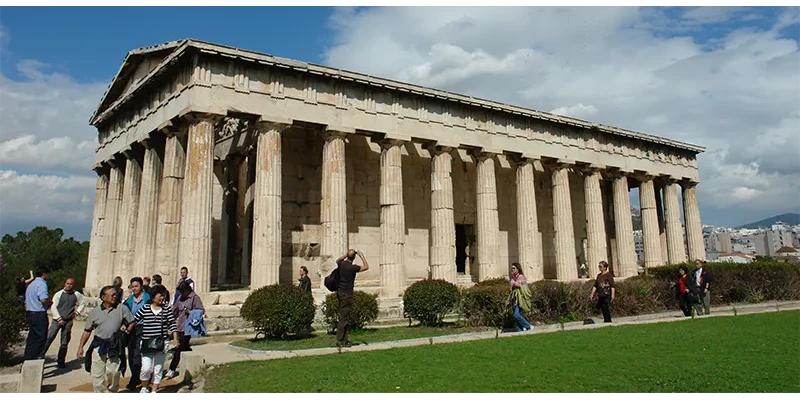
Greece divides neatly into two trips, and this itinerary does both. The first half is a cruise through the eastern Aegean and the Cyclades, calling at five islands that could not be less alike. The second half is the classical tour of the mainland by road, taking in the great sites of the ancient world in the order the landscape presents them. It finishes in Athens.
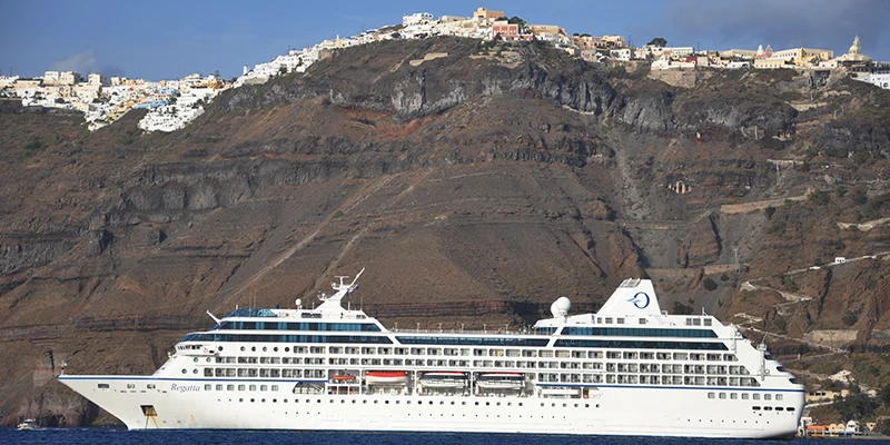
The logic of the combination is simple. The islands are scattered across a great deal of water and reaching more than one or two of them independently eats days. A ship covers the distance overnight while you sleep. The mainland sites, by contrast, are strung along a road and are far better seen from one, with the freedom to stop where you want.
.webp)
Ten days covers it comfortably: three or four on the ship, five on the road, and two at the end in Athens. That is the shape of the itinerary that follows. It can be shortened by cutting the Peloponnese loop, or lengthened by adding island time at either end.
Sailing from Athens
.webp)
The ship leaves from Piraeus, the port of Athens, seven miles southwest of the city center and connected to it by metro. Piraeus has been Athens's harbor since the fifth century BC, when the Long Walls ran down to it from the city, and it is still one of the busiest passenger ports in the world.
.webp)
Sailing is at midday, and the afternoon is spent crossing open water eastward. Meals aboard are included, which removes a good deal of daily decision-making, and the first evening at sea is the moment the trip changes gear from travel to holiday.
Patmos
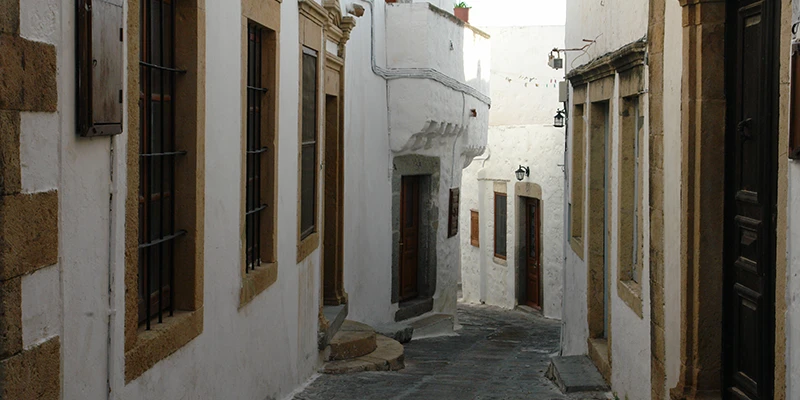
Patmos is small, quiet and, by the standards of the Greek islands, largely undeveloped. The ship arrives in the afternoon at Skala, the port, which sits on a narrow neck of land with the hilltop town of Chora above it. There is nothing frantic about the place; the whole island holds around three thousand people.
.webp)
The island's importance is religious. St John was exiled here in the first century, and tradition holds that the Book of Revelation was dictated to him in a cave on the hillside. The Cave of the Apocalypse is now a chapel built around the rock, and the pilgrimage to it has been continuous for a very long time.
.webp)
Above it stands the Monastery of St John the Theologian, founded in 1088 and built like a fortress against pirates, with high gray walls and a maze of chapels and courtyards inside. Its treasury holds icons, manuscripts and vestments of real importance, and the whole complex is a World Heritage Site along with the cave and the medieval town around it.
.webp)
Chora, the town below the monastery walls, is a knot of whitewashed lanes and sea captains' houses, and it is worth the walk up simply for the view back down over the harbor. The ship sails again in the evening.
Rhodes
.webp)
Rhodes gets a full day, and it needs one. The old town inside the walls is the largest inhabited medieval town in Europe, laid out by the Knights of St John after they took the island in 1309 and held it for two centuries until the Ottomans forced them out.
.webp)
The Street of the Knights runs uphill in a straight line of honey-colored stone, lined with the inns of the different national tongues of the order — France, Spain, Italy, England, Provence. It is the most complete medieval street of its kind anywhere, and it is largely empty in the early morning.
.webp)
At the top stands the Palace of the Grand Master, which was wrecked by an explosion in the nineteenth century and rebuilt by the Italians in the 1930s. The reconstruction is not archaeologically pure, but the mosaic floors brought in from Kos are genuine Roman work and the scale of the building is right.

The island is called the Island of Roses, and it was also the site of the Colossus, the bronze statue of Helios counted among the Seven Wonders. It stood for barely fifty years before an earthquake brought it down in 226 BC, and nothing of it survives. The popular idea that it straddled the harbor entrance is a medieval invention.
.webp)
An excursion down the east coast reaches Lindos, forty miles south, where a village of white cubic houses sits below an acropolis on a headland. The Temple of Athena Lindia at the top dates to the fourth century BC, and the view from it across the bay and the sea beyond is the best on the island.
Crete
.webp)
Morning brings the ship into Heraklion on Crete, the largest of the Greek islands and large enough to feel like a country of its own — a hundred and sixty miles long, with mountains running the length of it and villages that had their own dialect within living memory.
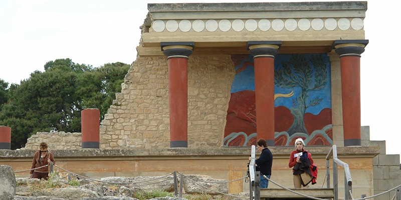
Knossos lies three miles inland and is the reason most visitors come. This was the principal palace of the Minoan civilization, occupied from around 1900 BC, a complex of over a thousand rooms arranged around a central court — the labyrinth of the Minotaur legend, in all probability.
.webp)
Sir Arthur Evans began excavating in 1900 and spent thirty years and his own fortune on it. He also rebuilt substantial parts of it in concrete, painted in what he took to be the original colors, which archaeologists have argued about ever since. It makes the site far easier to understand than a field of foundations and it is not, strictly, what was there.
.webp)
The original frescoes are in the Heraklion Archaeological Museum in town, along with the Phaistos Disc and the bull-leaping panels, and half an hour there does more for understanding Knossos than an hour at the site itself. The ship sails again at noon.
Santorini
.webp)
Nothing prepares you for the approach to Santorini. The ship sails into what is left of a volcano — a flooded caldera five miles across, with cliffs rising twelve hundred feet on three sides and the white town of Thira strung along the rim like snow on a ridge.
.webp)
The explosion that produced it happened around 1600 BC and was among the largest in recorded history, burying the Minoan settlement at Akrotiri under ash and, by one long-standing theory, contributing to the collapse of Minoan civilization on Crete a century or so later. The Atlantis connection is a nineteenth-century idea and remains speculation.
.webp)
Thira, also called Fira, sits nine hundred feet above the water. You get up by cable car, on foot up the zigzag of steps, or by donkey, and the cable car is the sensible choice in both directions. The town is a warren of white lanes, blue domes and terraces hanging over the drop.
.webp)
Oia at the northern tip is the smaller and prettier of the two towns and the traditional place to watch the sunset, which draws a crowd every evening in season. If the ship is in port late it is worth the bus ride; if not, the view from Thira is the same view.
Mykonos
.webp)
The cruise finishes at Mykonos, and the contrast with everything before it is the point. Patmos is monastic, Rhodes medieval, Crete archaeological and Santorini geological. Mykonos is none of those things. It is a bare, low, rocky island with almost no antiquities of its own, and it has become one of the most fashionable places in the Mediterranean on the strength of its looks and its nightlife.
.webp)
Mykonos Town, called Chora, is the finest example of Cycladic architecture anywhere — sugar-cube houses in whitewash, painted doors and shutters in blue and red, bougainvillea over the walls, and lanes so narrow and so deliberately tangled that the standard explanation is that they were laid out to confuse raiding pirates.
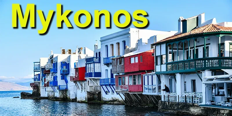
Little Venice is the row of eighteenth-century merchant houses along the western waterfront with their balconies hanging directly over the sea. The bars behind them are the sunset spot, and on a rough day the spray comes up over the tables. Above it stand the windmills, five or six of the sixteen that once ground the island's grain.
.webp)
Paraportiani, beside the old harbor, is the most photographed church in Greece — five separate chapels merged over several centuries into a single lumpy white mass with no straight lines left in it. It looks less like architecture than like something poured.
.webp)
Delos lies half an hour offshore by boat and is the reason the island matters historically. It was held to be the birthplace of Apollo and Artemis, was the treasury of the Athenian empire, and became one of the great trading ports of the Aegean. It has been uninhabited for centuries and the whole island is now an archaeological site — the House of the Masks, the theater quarter, and the terrace of marble lions.
Ashore: Corinth
.webp)
The ship returns to Piraeus overnight, and disembarkation begins the classical tour. The road west out of Athens reaches the Corinth Canal in about an hour, and almost everyone stops. The cut runs four miles through the isthmus but is only around thirty yards wide, its sheer rock walls dropping straight to the narrow channel below. A pedestrian lane along the modern road bridge gives a clear view down the length of it.
.webp)
The idea of cutting the isthmus is ancient. In antiquity a paved roadway called the Diolkos hauled ships and their cargo bodily overland across the neck of land. Nero attempted an actual canal in AD 67, putting thousands of laborers to work with picks and shovels, and the plan was abandoned. It was not achieved until nearly two thousand years later, a little over a century ago.
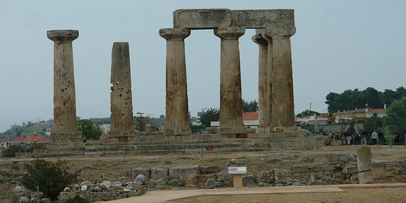
Ancient Corinth lies a few minutes further on and is one of the largest and most rewarding archaeological sites in Greece. What makes it unusual is that you see not an isolated temple but the outline of a whole ancient city — streets, shops, fountains and civic buildings spread across a plain beneath the standing columns of the Temple of Apollo.
.webp)
Corinth sits on the narrow isthmus joining the Peloponnese to the mainland, about an hour and a half west of Athens. Controlling the land route between eastern and western Greece, with harbors on two seas, made it one of the wealthiest cities of the classical world. It was briefly the capital of Greece, and later the Romans made it the capital of their Greek province.
.webp)
The Temple of Apollo is the oldest thing standing here, its heavy Doric columns dating from the sixth century BC. These are among the earliest Greek temple columns still upright, and each is carved as a single monolithic shaft rather than the stacked drums used later at the Parthenon. The squat proportions belong to the Doric order in its early stages, before it found the lighter balance of the following century.
.webp)
When Greece was liberated from Turkish rule, almost nothing of ancient Corinth was visible apart from that temple. Everything else lay buried under a village and centuries of accumulated earth. The level you walk on now is largely Roman, with the Greek layer about a meter deeper, and excavation by the American School of Classical Studies continues to this day.
.webp)
The main Roman road runs through the site lined with the foundations of shops, leading toward the civic center with its fountains and baths. The Roman city dates essentially from the time of Julius Caesar, around 44 BC, and flourished for close to four centuries on top of the earlier Greek town.
.webp)
Among the most notable structures is the Fountain of Peirene, fed by underground basins formed naturally in the clay and conglomerate of the Peloponnese. One of its arched chambers was later converted into an early Christian church, which is largely why it survived. Fountains are everywhere here precisely because the surrounding land holds so much water.
.webp)
Well-preserved steps, terraces and platforms give a strong sense of how the city actually functioned, which is the thing most classical sites cannot offer. Above it all stands Acrocorinth, the enormous rock that served as the citadel, crowned by fortifications from every era that ruled here.
.webp)
The site museum is small and worth the time. It traces the development of pottery styles across the centuries and holds floor mosaics preserved from the Roman period, their central medallions still showing finely worked figures.
.webp)
The statue gallery holds Roman emperors and provincial governors associated with the city, many of them draped figures whose missing heads are typical of sculpture recovered from long-buried sites. Everything on view came out of the ground you have just walked over, so the objects and their setting explain one another directly.
Epidaurus
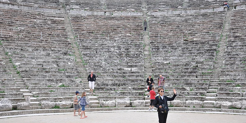
Epidaurus lies an hour south into the Peloponnese, and its theater is the best preserved in Greece. Built into a hillside in the fourth century BC, it holds fourteen thousand people in fifty-five tiers of limestone seating and is still used for performances every summer.
The acoustics are the famous thing and they are not exaggerated. A coin dropped on the floor of the orchestra is audible in the top row, and every guide demonstrates it. The effect comes from the geometry of the limestone seating, which filters low-frequency background noise while reflecting the higher frequencies of a voice.
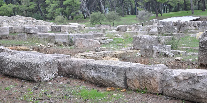
The theater was part of a much larger sanctuary of Asklepios, the god of healing, which functioned as a hospital and spa for several centuries. Patients slept in the abaton and reported their dreams to the priests, and the inscribed accounts of their cures survive.
Nafplion
.webp)
Nafplion, on the Gulf of Argolis, is where the night is spent, and it is the most attractive town in the Peloponnese. Venetian and Ottoman buildings line the old streets, the waterfront is a run of cafés, and a small fortress called the Bourtzi sits on an islet in the middle of the harbor.
.webp)
The Palamidi fortress on the crag above was built by the Venetians in the 1710s and taken by the Turks after barely a year. The stairway up from the town is traditionally said to have a thousand steps; the real count is nearer nine hundred, and the road is an easier option.
.webp)
Nafplion was the first capital of independent Greece, from 1829 until the government moved to Athens in 1834, and the first governor was assassinated on the steps of one of its churches. For a town this size it carries a remarkable amount of history lightly.
Mycenae
.webp)
A short drive north of Nafplion, Mycenae sits on a low hill between two mountains. It was the center of the civilization that dominated Greece from about 1600 to 1100 BC — the world Homer was describing several centuries after it had gone. The Lion Gate at its entrance, with two lionesses flanking a column above the lintel, was carved around 1250 BC and has stood in the open air ever since.
.webp)
Below the citadel is the Treasury of Atreus, a beehive tomb cut into the hillside with a corbelled dome forty-three feet high — the largest unsupported span in the world for a thousand years after it was built. Standing inside it, in the dark, is the strongest experience the site offers.
.webp)
Heinrich Schliemann dug here in 1876 and found the shaft graves with their gold masks, one of which he identified as Agamemnon's. It was in fact three centuries too early for any Trojan War, but the name has stuck and the mask is now in the National Archaeological Museum in Athens.
Olympia
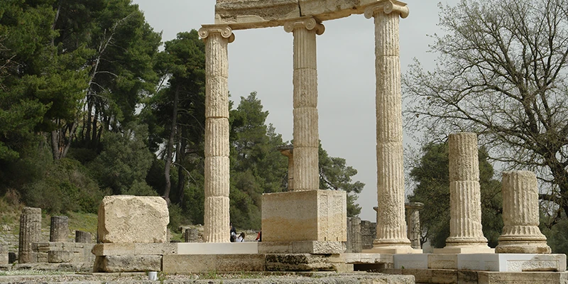
The road west across the Peloponnese reaches Olympia in a morning. The setting is a green valley between two rivers, wooded and quiet, and it comes as a surprise after the dry hills — this is one of the few classical sites in Greece that is pleasant simply as a place to walk.
.webp)
The Games were held here every four years from 776 BC until the Christian emperors suppressed them in AD 393, a run of nearly twelve centuries. The Temple of Zeus at the center held Phidias's forty-foot statue of the god in gold and ivory, another of the Seven Wonders, which was lost after being carried off to Constantinople.
.webp)
The stadium is entered through a vaulted tunnel and is simply a flat run of grass between earth banks, with the stone start and finish lines still in place, six hundred Olympic feet apart. There were no seats. Forty-five thousand spectators stood on the banks.
.webp)
The museum beside the site is one of the best in Greece. It holds the pediment sculptures from the Temple of Zeus, the Nike of Paionios, and the Hermes attributed to Praxiteles, which was found where Pausanias said it would be, in the Temple of Hera, seventeen centuries after he wrote about it.
Across to Delphi
.webp)
The route north crosses the Gulf of Corinth on the Rio–Antirrio bridge, which opened in 2004 and is among the longest cable-stayed bridges in the world at nearly two miles. It replaced a ferry that took forty-five minutes, and the crossing now takes five.
.webp)
Beyond it the road runs east along the northern shore of the gulf through the plains of Achaia and Aetolia, with the water on one side and mountains on the other, to the small port of Itea. From there it climbs into the hills to Delphi.
Delphi
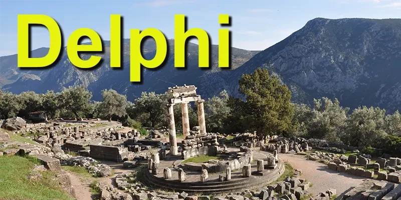
Delphi is built into the side of Mount Parnassus above a valley of olive groves running down to the sea, and it is the most dramatically placed site in Greece. The ancient Greeks called it the navel of the world and marked the spot with a carved stone, the omphalos, on the theory that two eagles released from opposite ends of the earth had met here.
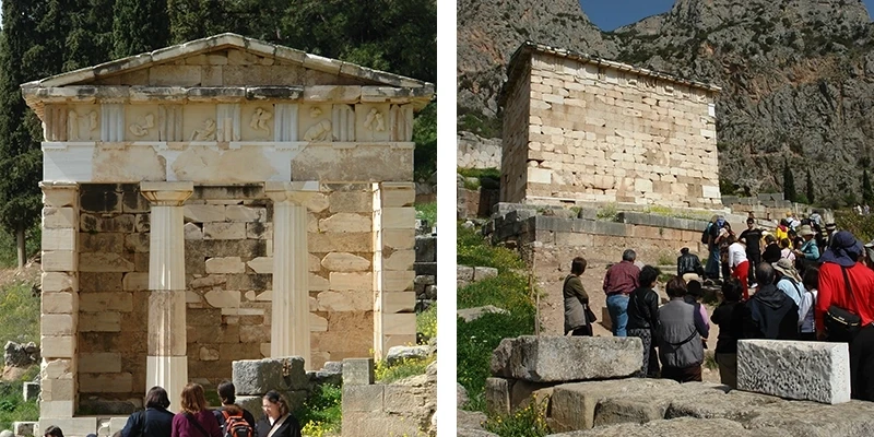
The Sacred Way climbs through the sanctuary in a series of switchbacks, lined with the ruins of treasuries built by individual cities to house their offerings. The Treasury of the Athenians, reconstructed from its own fallen blocks in 1906, gives the best sense of what the crowd of them looked like.
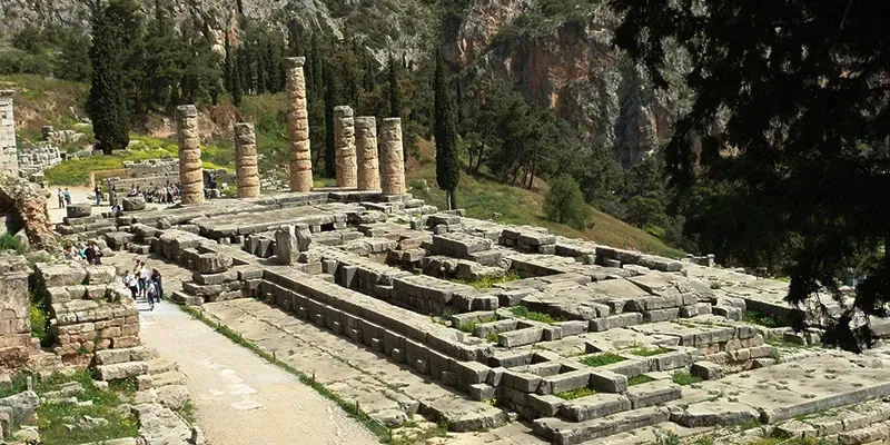
At the top stands the Temple of Apollo, where the Pythia delivered the oracle. She sat over a cleft in the rock and spoke in a state the ancient sources describe as trance; geologists have since found faults beneath the temple releasing ethylene gas, which would account for it. Her answers were famously ambiguous.
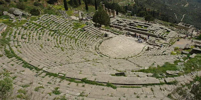
Above the temple is the theater, and above that the stadium, which is the best preserved in Greece and still has its stone seating. The climb is steep and worth making for the view back down over the whole sanctuary with the valley beyond.
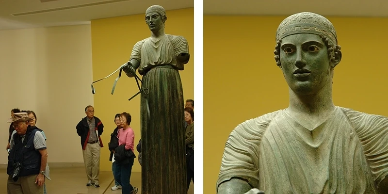
The museum holds the Charioteer, a life-size bronze from around 478 BC that survived because an earthquake buried it. The eyes are inlaid with glass and stone and the eyelashes are separate strands of bronze. It is among the finest surviving works of the early classical period and it is worth the trip on its own.
.webp)
Below the road, on a separate terrace, is the Sanctuary of Athena Pronaia, and in it the tholos — a circular building of the fourth century BC with three of its columns re-erected. Nobody knows what it was for. It is the single most photographed structure at Delphi.
Meteora
.webp)
North of Delphi, on the plain of Thessaly, sandstone pillars rise several hundred feet straight out of flat ground, and on top of them sit monasteries. There is nothing else like it. The rock formations are the remains of a river delta eroded over millions of years, and the effect from below is of buildings suspended in the air.
.webp)
Hermits took to the caves in the eleventh century and the first monasteries went up in the fourteenth, reached only by rope ladders and nets hauled up by windlass — a system still in use within living memory. Steps were cut into the rock in the 1920s. Of twenty-four monasteries, six are still active.
.webp)
The interiors hold Byzantine wall paintings of the sixteenth century, dark with candle smoke and remarkably intact. Each monastery keeps its own opening days, so the itinerary usually takes in two or three rather than trying for all six. Modest dress is required and enforced.
The Road Back to Athens
The route south to Athens passes Thermopylae, where three hundred Spartans and several thousand allies held the pass against the Persian army for three days in 480 BC. The sea has retreated and the narrow gap between mountain and shore is now a wide plain, so the site takes some imagining, but the monument to Leonidas stands beside the road.
.webp)
Beyond it the road runs down the coast through Lamia and the spa town of Kamena Vourla, reaching Athens in the evening. It is a long day, and the last of the driving.
Athens

The city tour begins at Syntagma Square in front of the Parliament, which was built as the royal palace in the 1830s when Athens was a town of a few thousand people and had just been made the capital of the new kingdom.

The Tomb of the Unknown Soldier is set into the wall below it, guarded by the Evzones in their pleated skirts, woolen leggings and shoes with pompoms — a uniform derived from the mountain fighters of the war of independence. The changing of the guard happens on the hour and the full ceremony on Sunday morning.

Driving down past the Presidential Palace, the route reaches Hadrian's Arch, put up in AD 131 to mark the boundary between the old Greek city and the new Roman quarter, with an inscription on each side saying exactly that.

Behind it stand the columns of the Temple of Olympian Zeus, begun in the sixth century BC and left unfinished for six hundred years until Hadrian completed it. Sixteen of the original hundred and four columns survive, standing sixty feet high, one of them lying where a storm dropped it in 1852.

A short stop takes in the Panathenaic Stadium, rebuilt entirely in white marble for the first modern Olympic Games in 1896 on the foundations of the Roman stadium of AD 144. It seats sixty thousand and is the only stadium in the world built wholly of marble.

Then the Acropolis. You enter through the Propylaea, the monumental gateway of the 430s BC, climbing a ramp between columns that were designed to frame the approach and still do exactly that.

To the right, on a bastion above the entrance, is the small Temple of Athena Nike, built around 420 BC, taken apart and reassembled three times in the modern era for restoration and now standing on its original footprint.

The Erechtheion on the north side is the oddest building on the rock, built on several levels to accommodate the shrines and the sacred olive tree it had to enclose. Its south porch is carried by six caryatids — the ones in place are copies, five originals are in the museum below and the sixth is in London.

The Parthenon was built between 447 and 432 BC and stood essentially intact for more than two thousand years, serving as a church and then a mosque, until a Venetian shell hit the Ottoman powder magazine stored inside it in 1687 and blew the middle out of it. Restoration has been continuous since 1975.

The Acropolis Museum opened at the foot of the hill in 2009, built over an excavated ancient neighborhood which you walk above on glass floors. Its top floor is a gallery the exact size and orientation of the Parthenon, holding the surviving sculpture in its original arrangement with the Acropolis visible through the windows.

Below the Acropolis is the Plaka, the old quarter of nineteenth-century houses, tavernas and shops that survived the rebuilding of the city. Anafiotika, at its upper edge, was built by workmen from Naxos in the 1840s and looks like an island village dropped onto the hillside.

A free day at the end is worth keeping. The National Archaeological Museum holds the Mycenaean gold, the bronzes and the Antikythera mechanism and needs half a day. The Monastiraki market, the ancient Agora and a coastal trip to the temple at Cape Sounion are the obvious alternatives.
When to Go and How Long
.webp)
April to early June and September to October are the months. July and August are hot enough to make midday at an unshaded archaeological site genuinely unpleasant, and the islands are at their most crowded and most expensive. Spring has wildflowers among the ruins; autumn has warmer sea.
.webp)
Ten days is the working minimum for this route. The cruise portion is fixed by the ship's schedule; the mainland portion can be driven independently in a rental car at whatever pace suits, and Nafplion, Olympia, Delphi and Kalambaka all have good small hotels. Doing it by public bus is possible but adds days.

Site admissions add up, so check whether a combined ticket covers what you plan to see. Bring a hat, water and shoes with grip — the marble at every classical site in Greece has been polished by several million visitors and is slippery. And leave time in the evenings, which is when Greece is at its best and when almost nothing is scheduled.