Sicily, which is the largest island in the Mediterranean Sea, occupies the crossroads where Europe meets Africa and the eastern basin converges with the western. This geography created a history of successive occupations, each leaving architectural and cultural traces that accumulate in cities showing Greek temples beside Norman churches, Arab markets adjacent to baroque palaces, and Spanish fortifications overlooking modern ports. The island's scale allows traversing from coast to coast in hours, yet each city presents distinct character shaped by its particular history, economic role, and relationship to surrounding landscape.
Palermo, 2 nights; then 1-hour train to Cefalù
Cefalù, 3 nights, then 3-hour train to Taormina
Taormina, 3 nights, then 3-hour train to Siracusa
Siracusa, 4 nights, then 2-hour train to Catania
Catania, 4 nights, then 2 1/2 hr bus to Palermo
Palermo, 5 nights, then fly out
Following is a summary of the recommended sequence of places, with detailed stories listed alphabetically in the sidebar.
We have individual pages about each of these destinations, filled with information about the historic sights, shopping streets, gardens, scenic vistas and more, linked in the sidebar. Each page also has a summary Top-20 list of the most important sights.

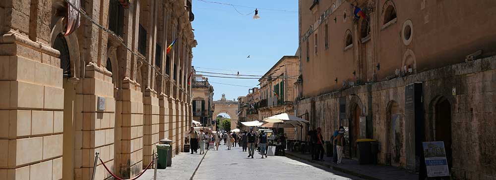
Palermo, capital of Sicily, spreads across a coastal plain between mountains and harbor, a configuration that attracted Phoenician traders, Roman administrators, Arab emirs, and Norman kings. The Norman Palace demonstrates this layering most dramatically, incorporating Punic foundations, Roman walls, and Arab fortifications beneath Norman construction. The Palatine Chapel inside shows Arab craftsmen working for Norman rulers, creating mosaics in Byzantine tradition with Arabic inscriptions and muqarnas ceilings. The synthesis produces interiors where Christ Pantocrator gazes from gold mosaic domes above geometric Islamic patterns and Latin liturgical texts.
The cathedral presents a different synthesis, its Norman structure modified by Gothic additions, baroque interiors, and neoclassical dome. The building records architectural fashion changes across seven centuries, with each period adding rather than replacing. The street markets occupy medieval footprints where vendors sell produce, seafood, and prepared foods in covered alleys. Ballaro, Vucciria, and Capo markets maintain commercial patterns from the Arab period though goods and customers have changed. Quattro Canti marks the baroque intersection where Spanish planners divided the medieval city into quadrants, creating urban scenery where architecture frames views along four streets radiating from the central point.
.jpg)
Cefalù occupies a coastal position on Sicily's northern shore approximately seventy kilometers east of Palermo, easily reached in one hour by car or regional train services that operate frequently throughout the day. The medieval town extends along a crescent beach beneath La Rocca, a massive limestone promontory that rises four hundred meters above sea level and provides the settlement's most recognizable landmark. The historic center maintains narrow streets with buildings dating from Norman, Arab, and medieval periods, contrasting with the baroque architecture dominant in southeastern Sicily.
The waterfront extends along Lungomare Giardina where restaurants, cafes, and hotels occupy buildings facing the beach. The sandy shore attracts swimmers during summer months when coastal waters reach comfortable temperatures. The medieval wash house, Lavatoio Medievale, survives as a covered stone structure where residents once cleaned clothing using water channeled from natural springs.

Taormina perches on a hillside terrace two hundred meters above the Ionian Sea, a position offering defensive advantage and spectacular views. The Greek Theater occupies the most dramatic location where the ancient cavea frames Mount Etna and the coastline beyond the stage, creating theatrical backdrop that combines architecture with volcanic and maritime scenery. The medieval town extends along a single ridgeline street, Corso Umberto, connecting two city gates a kilometer apart. This pedestrianized thoroughfare concentrates tourist activity along a linear route where nearly every building serves commercial functions.
Piazza IX Aprile provides the principal viewing platform where a terrace square opens to panoramas encompassing the Bay of Naxos, Calabrian mountains, and Etna's profile. The cable car connects the hilltop town with Mazzaro beach below, allowing visitors to combine cultural tourism with beach recreation within a compact area. The dual character as both historic site and seaside resort distinguishes Taormina from purely cultural or purely recreational destinations.

Catania spreads across the plain at Etna's southern base, positioned where lava flows reach the Ionian coast. The sixteen ninety-three earthquake and subsequent eruption devastated the city, and the reconstruction created the baroque urban landscape visible today. Piazza del Duomo demonstrates baroque planning principles with the cathedral, Palazzo degli Elefanti, and Amenano fountain creating coordinated architectural ensemble. The elephant fountain at the center displays Catania's symbol, a lava stone elephant carrying an Egyptian obelisk.
The cathedral dedicated to Saint Agatha shows facade designed by Giovanni Battista Vaccarini using local lava stone creating dark grey coloring that distinguishes Catanian baroque from the golden limestone of other Sicilian cities. Via Etnea provides the main commercial axis running straight from the harbor toward Etna's slopes, creating vista toward the volcano that dominates the city's geography. Castello Ursino survives from the thirteenth century as one of the few pre-earthquake structures remaining substantially intact, built by Frederick II as coastal defense though lava flows extended the shoreline, leaving the castle inland.

Siracusa developed as one of the ancient world's most powerful cities, a Greek colony founded in seven thirty-four BC that became metropolis rivaling Athens. The city occupied both the island of Ortygia and the mainland shore, creating a configuration where the historic core on the island connects by bridge to the archaeological park and modern city on the mainland. The Archaeological Park preserves the Greek theater carved into hillside with cavea maintaining ancient form used for classical performances. The Roman amphitheater shows later addition serving different entertainment with arena for gladiatorial contests.
Ortigia presents a dense urban island where Greek street patterns underlie medieval and baroque buildings. The cathedral demonstrates architectural layering most dramatically, incorporating columns from the fifth-century BC Temple of Athena within its walls. The temple's Doric columns remain visible inside the baroque church and embedded in the exterior walls, showing how Christian worship occupied pagan sacred space. The Arethusa Fountain provides the island's freshwater source, a spring creating a circular pool where papyrus grows. Piazza del Duomo creates baroque urban space where the cathedral facade, Palazzo Senatorio, and coordinated buildings form an architectural ensemble. Castello Maniace occupies the island's southern point, a thirteenth-century fortress built by Frederick II showing Swabian military architecture.
The Val di Noto comprises eight towns in southeastern Sicily rebuilt after the catastrophic sixteen ninety-three earthquake.. The reconstruction created baroque urban landscapes that UNESCO recognized as collective World Heritage site for their coordinated architectural expression and town planning. Noto represents the most complete expression of baroque planning, built on a new site with three parallel streets running along hillside contours. The principal axis contains the cathedral, Palazzo Ducezio, and church of San Carlo creating sequential architectural set pieces using local golden limestone. You could easily reach Noto on a day-trip from Siracusa with a one-hour bus ride.
Ragusa occupies a divided topography where the reconstruction created two distinct centers connected by staircases traversing steep terrain. Ragusa Ibla presents atmospheric character with baroque churches and palaces occupying the slopes. Modica spreads through a narrow valley where buildings ascend hillsides on both sides of the former riverbed. The cathedral of San Giorgio occupies an elevated position reached by flight of two hundred fifty steps. The Val di Noto towns demonstrate how coordinated reconstruction created architectural unity while each town adapted principles to specific geography.
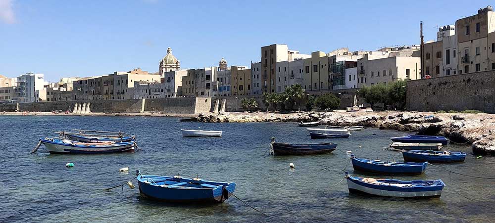
You could reach Trapani as a day trip from Palermo with a 90-minute bus ride. Trapani extends along a curved promontory on Sicily's western coast, a sickle-shaped peninsula that gave the city its name. The geography created natural harbors on both sides of the peninsula and positioned Trapani as western Sicily's primary port. The salt pans south of the city continue production methods from Phoenician times, creating landscape of shallow rectangular pools where seawater evaporates leaving salt deposits. Windmills used for pumping water punctuate the geometry of the pans, creating distinctive scenery where white salt mounds, reflecting pools, and traditional windmills compose views that attract photographers.
The historic center occupies the peninsula's narrow width with streets running the length of the promontory and alleys crossing between the two waterfronts. The medieval street plan survives with baroque churches including the cathedral and sanctuary of Maria Santissima Annunziata showing reconstruction after various disasters. The fish market near the port operates in covered structure where vendors display daily catch including tuna, swordfish, and seafood from surrounding waters, maintaining commercial traditions connected to Trapani's maritime economy.
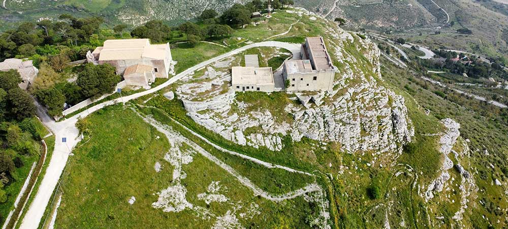
Erice occupies a mountain peak at seven hundred fifty meters elevation directly inland from Trapani, accessible by cable car or winding road climbing through twenty-six switchbacks. The elevation creates climate distinct from coastal Trapani with cooler temperatures and frequent fog that enhances the medieval ambiance. Stone buildings, narrow cobbled streets, and defensive walls preserve character largely unchanged since medieval consolidation. The town served as sacred site from ancient times when temple to Venus Erycina attracted pilgrims from across the Mediterranean.
The Norman castle occupies the summit where Venus temple foundations remain visible, demonstrating continuity of sacred and strategic use. The Balio gardens adjacent to the castle provide landscaped space with views extending across western Sicily to Trapani, the salt pans, and the Egadi Islands. The Venus castle stands on a separate rocky outcrop where worship of Venus Erycina combined Greek Aphrodite, Phoenician Astarte, and local fertility goddess traditions. Medieval streets wind through the compact town center where buildings show Norman construction in local grey stone. The Chiesa Madre dedicated to the Assumption shows fortress-like facade with crenellations reflecting the town's defensive character. The combination of sacred history, defensive position, craft traditions, and dramatic setting establishes Erice as destination offering experience different from beach resorts and baroque cities elsewhere in Sicily.